Cuts & Pastes
"This is not a typical storm," said Pennsylvania Gov. Tom Corbett. "Essentially, this is a hurricane wrapped in a 'nor'easter.'"
Northerly track: Atlantic tropical storms most commonly tear through the Caribbean and the Gulf of Mexico, and lose energy as they pass over the U.S mainland. This storm, however, crept along the Eastern Seaboard, where waters that were warmer than usual for this time of year kept the storm alive. As the storm moved northward, it morphed into a hybrid storm, drawing additional strength from the differential between the storm's warm air and cold northern air from the jet stream.
"There's a transformation that this system is undergoing," Landsea explained. "This is actually evolving into a winter storm, and later, a nor'easter." One result of this evolution is that the storm system has widened to more than 800 miles in diameter, stretching from the Carolinas to Maine and Canada.
The left turn: Hurricanes that get so far north could drift off into the cold Atlantic to die — but they can also be pushed into the mainland, as Hurricane Irene was last year. Irene followed a path that was roughly parallel to the coastline, but Sandy took a hard left turn that put it on a course for a direct, perpendicular strike on the coast. That's because a cold front on the mainland is drawing the storm westward, while the current state of a weather pattern known as the North Atlantic Oscillation is blocking the storm from heading eastward.
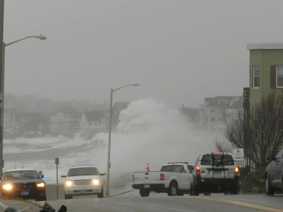
Storm surge: Sandy's top sustained winds of 85 miles per hour typically wouldn't rate as a superstorm, but its effects will be magnified, Landsea said. "Even though it's not a 'major' hurricane by any means ... there is substantial threat because of the storm surge and because of the rainfall. There's going to be flooding. Both of those factors are going to be killers," he said. The storm surge is projected to range from 6 to 11 feet. One of the big reasons for such a high surge is that the waters off the coast of New York and New Jersey are so shallow: As the surge from the deeper ocean nears the coastline, all that water piles up to create a higher wave.
Full moon: Another reason for the huge storm surge is the fact that the moon is hitting its full phase just as Sandy is making landfall. The celestial lineup of the sun, moon and Earth contributes to higher-than-normal high tides.
(An all-time record tide level of 13.88 feet was set at The Battery in Lower Manhattan on Monday night, breaking the previous record of 11.2 feet in 1821).
Winter storm: Sandy is such a late-season storm that it's running into winter weather in the northeastern United States, which is adding an extra dimension to the misery. "I have not been around long enough to see a hurricane forecast with a snow advisory in it," Craig Fugate, administrator of the Federal Emergency Management Agency, told NBC's TODAY. The storm could trigger up to 3 feet of snow in the Appalachians, the National Weather Service reported. The Weather Channel's Tom Niziol said that "an amazing combination of factors" have come together to make Sandy a threat due to the snow as well as the rain.
Landsea and other forecasters may marvel at the factors behind what some have called a "perfect storm" or "Frankenstorm," and there'll surely be lots of lessons learned for future weather modeling.
:cat: :face: :study:


 ale:
ale:


![[3-Size Set] Copper Pipe Cleaner for Drill, Clean 1/2, 3/4, 1-in Copper Pipes & Tubes for Soldering, 3 Tube Cleaning Brushes, Model InerLok050, 075, 100, w/ Stainless-Steel Wire Bristles & 1/4” Shank](https://m.media-amazon.com/images/I/41QVxunlqML._SL500_.jpg)