You are using an out of date browser. It may not display this or other websites correctly.
You should upgrade or use an alternative browser.
You should upgrade or use an alternative browser.
Sierra-bound
- Thread starter Vito
- Start date
Help Support Brothers of Briar:
This site may earn a commission from merchant affiliate
links, including eBay, Amazon, and others.
Beautiful Veet! Enjoy.....
.......and take your fly rod.............
8)
Cheers,
RR
.......and take your fly rod.............
8)
Cheers,
RR
loneredtree
Well-known member
- Joined
- May 28, 2011
- Messages
- 333
- Reaction score
- 0
I was in the Banner Ritter area last year. We went in the High trail and out the John Muir trail. I hope you Enjoy it.
:bounce: :bounce: :bounce:
:bounce: :bounce: :bounce:
Thanks, RR. The only rod I'm taking is the one I was born with, and I won't be using it on any fish. This is ...er, a spiritual trip. :mrgreen:Brewdude":995ndvhe said:Beautiful Veet! Enjoy.....
.......and take your fly rod.............
Actually, that's close, loneredtree. I'm headed for the Minarets, just south of Ritter. Really looking forward to this...loneredtree":995ndvhe said:I was in the Banner Ritter area last year...
YOW!


loneredtree
Well-known member
- Joined
- May 28, 2011
- Messages
- 333
- Reaction score
- 0
Are starting from Agnew Meadow? If you camp the first night at the campground they let you drive in and then park at the trail head the next day BTW.
A
Anonymous
Guest
Enjoy ! 8)
:face:
:face:


$9.99
Loftus International Detective Sherlock Hat & Pipe 2pc Accessory Kit Grey One Size Novelty Item
Fancy Friends Distribution


$65.00 ($65.00 / Count)
Fashion Briar Churchwarden Tobacco Smoking Pipe MORBEDRE Bent BILIARD (ENA) 265 mm/10.6in Wood Handcrafted. Designed for Pipe Smokers
Fashion Pipes

![[3-Size Set] Copper Pipe Cleaner for Drill, Clean 1/2, 3/4, 1-in Copper Pipes & Tubes for Soldering, 3 Tube Cleaning Brushes, Model InerLok050, 075, 100, w/ Stainless-Steel Wire Bristles & 1/4” Shank](https://m.media-amazon.com/images/I/41QVxunlqML._SL500_.jpg)


$4.29
$5.99
Audrey Style Vintage Extendable Cigarette Holder in Black Inspired by BAT's
BrightSummit


$23.00 ($2.09 / Count)
MUXIANG Tobacco Pipe Ebony with 9mm Filter 10 Cleaning Pipe Tools AC0035
XIAOXIONGCRAFTS

Briar Spirit
Well-known member
- Joined
- Aug 30, 2012
- Messages
- 2,660
- Reaction score
- 0
Have a wonderful time, wish I could go with you Buddy, look forward to your tantalising report upon your return. ")
Thanks Kirk and Yak.
I'll go in at the Minaret Lake trailhead, just south of Minaret Falls campground. The John Muir Trail (North) heads NNW from there, and then Minaret Lake trail breaks off toward the west near Johnston Meadow, and follows Minaret Creek. I've been up that way before. It's nice.
Agnew Meadows campground is closed and probably won't open until next year. Vehicles are not permitted past Minaret Vista. The only access beyond that point and down into Reds Meadow is via mandatory shuttle. They won't even let hikers walk up or down Reds Meadow Road. Apparently they're still cleaning up from the massive windstorm damage in 2011, November.loneredtree":02hybnex said:Are starting from Agnew Meadow? If you camp the first night at the campground they let you drive in and then park at the trail head the next day BTW.
I'll go in at the Minaret Lake trailhead, just south of Minaret Falls campground. The John Muir Trail (North) heads NNW from there, and then Minaret Lake trail breaks off toward the west near Johnston Meadow, and follows Minaret Creek. I've been up that way before. It's nice.
loneredtree
Well-known member
- Joined
- May 28, 2011
- Messages
- 333
- Reaction score
- 0
Things have changed since last year.
Yes, the damage from that storm is impressive. The trees form the JMT to the Agnew Meadow parking lot were stacked 15- 20 feet high.
Have a good trip.
Yes, the damage from that storm is impressive. The trees form the JMT to the Agnew Meadow parking lot were stacked 15- 20 feet high.
Have a good trip.
One of the Devil's Postpile rangers said they had winds up to 180 miles per hour in that storm. At first they thought they lost dozens of trees, then they revised it to hundreds, but ultimately they found that the storm took out thousands of trees.loneredtree":07i7ij4p said:...Yes, the damage from that storm is impressive...
Anyhow, it still beats hiking in the Puente Hills above the San Gabriel Valley. I'm outa here tomorrow. See y'all later... :mrgreen:
Well, it was a great idea, but the timing was wrong, courtesy of the Aspen wildfire in the Sierra National Forest.
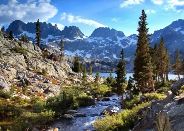
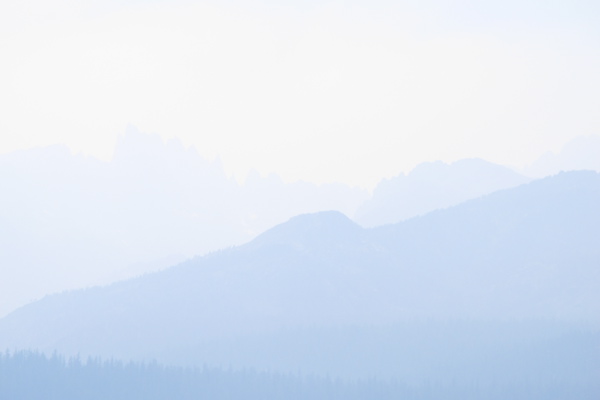
Case in point: Here's what the view from Minaret Vista is supposed to look like:
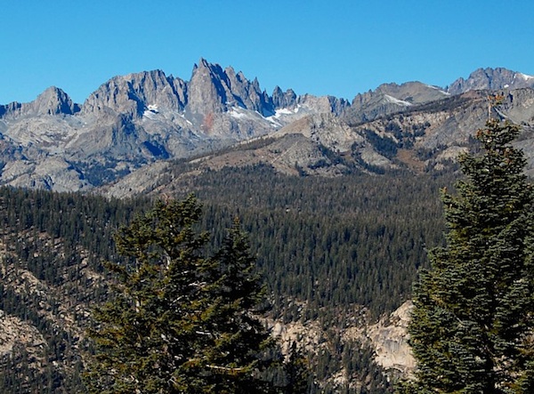
Here's what it looks like now:
The Mammoth Lakes air quality monitoring station showed the following PM-10 graphs (concentration of particles less than 10 microns) for the duration of my stay in the area:


Things looked to be improving (slightly) on July 31, but the spike just after midnight on August 1 was the deal-breaker. Acclimation was impossible...not just because of the high concentration of particulates (although that was bad enough), but because of the atmospheric carbon monoxide (CO) content. CO's ability to bond to hemoglobin is between 200 to 300 times that of molecular oxygen, so it gloms onto the hemoglobin cells and saturates them...meaning, they can't bind oxygen. You can breathe as hard and as fast as you want, but you'll develop an oxygen debt just sitting around in camp. Light hiking is inadvisable; strenuous hiking is impossible. Camping at 9,000 feet felt like hoofing it at 14,000 feet.
The air quality folks finally issued a "Stage 1 Health Advisory" on Thursday, August 1, but by that time I already knew it was hopeless. The fire was only about 35% contained at that point, and the decision had already been made to let it burn up to the treeline. The terrain is brutally steep, and all they can do to get containment is try to cut firebreaks very far away from the fireline, where they have some kind of access, and let the fire burn up to them. That means the fire is going to be burning for many days to come.
To top it off, the winds were mostly out of the southwest, which drove the smoke smack dab toward Mammoth, where I was camped. I checked with the rangers at the Red Meadows Road entry station on Wednesday at about 5:00 p.m., and they said they were advising everyone to stay east of Minaret Summit Road — in other words, not to go exactly where I wanted to go. And they were advising people with respiratory issues (I'm mildly asthmatic) to get the hell outa Dodge. They expected the winds to kick up to around 30 mph on Wednesday night, bringing lots of new smoke into the area. That's exactly what happened.
Anyhow, after three mostly sleepless nights of hacking in a couple of Mammoth Lakes campgrounds (Lake Mary and Twin Lakes), waiting out the fire, I threw in the towel on Thursday, and headed for home. As of today, the fire is 50% contained, but even after they get full containment, they're just going to have to let a huge area burn itself out. It will be weeks before the area is habitable for anything but indoor living.
Feh. Great idea, bad timing. So it goes. The best laid plans of mice and men...etc. :whatthehell:
Case in point: Here's what the view from Minaret Vista is supposed to look like:
Here's what it looks like now:
The Mammoth Lakes air quality monitoring station showed the following PM-10 graphs (concentration of particles less than 10 microns) for the duration of my stay in the area:
Things looked to be improving (slightly) on July 31, but the spike just after midnight on August 1 was the deal-breaker. Acclimation was impossible...not just because of the high concentration of particulates (although that was bad enough), but because of the atmospheric carbon monoxide (CO) content. CO's ability to bond to hemoglobin is between 200 to 300 times that of molecular oxygen, so it gloms onto the hemoglobin cells and saturates them...meaning, they can't bind oxygen. You can breathe as hard and as fast as you want, but you'll develop an oxygen debt just sitting around in camp. Light hiking is inadvisable; strenuous hiking is impossible. Camping at 9,000 feet felt like hoofing it at 14,000 feet.
The air quality folks finally issued a "Stage 1 Health Advisory" on Thursday, August 1, but by that time I already knew it was hopeless. The fire was only about 35% contained at that point, and the decision had already been made to let it burn up to the treeline. The terrain is brutally steep, and all they can do to get containment is try to cut firebreaks very far away from the fireline, where they have some kind of access, and let the fire burn up to them. That means the fire is going to be burning for many days to come.
To top it off, the winds were mostly out of the southwest, which drove the smoke smack dab toward Mammoth, where I was camped. I checked with the rangers at the Red Meadows Road entry station on Wednesday at about 5:00 p.m., and they said they were advising everyone to stay east of Minaret Summit Road — in other words, not to go exactly where I wanted to go. And they were advising people with respiratory issues (I'm mildly asthmatic) to get the hell outa Dodge. They expected the winds to kick up to around 30 mph on Wednesday night, bringing lots of new smoke into the area. That's exactly what happened.
Anyhow, after three mostly sleepless nights of hacking in a couple of Mammoth Lakes campgrounds (Lake Mary and Twin Lakes), waiting out the fire, I threw in the towel on Thursday, and headed for home. As of today, the fire is 50% contained, but even after they get full containment, they're just going to have to let a huge area burn itself out. It will be weeks before the area is habitable for anything but indoor living.
Feh. Great idea, bad timing. So it goes. The best laid plans of mice and men...etc. :whatthehell:
Puff Daddy
Well-known member
- Joined
- Dec 9, 2007
- Messages
- 6,910
- Reaction score
- 98
That's almost as bad as the smog poisoning you'd have gotten if you'd have stayed home in LA :lol:
A
Anonymous
Guest
:shock:
:face:
:face:
HAR! :lol: Good one, PD.Puff Daddy":v07bn10y said:That's almost as bad as the smog poisoning you'd have gotten if you'd have stayed home in LA :lol:
Actually, things have changed since you were a local denizen in days of yore. On most days, we can see the San Gabriel Mountains from here, and on many days even the San Bernardino Mtns. That horrid, stinky, ugly brown layer of air sludge that made the L.A. basin live up to its Valley of Smoke moniker has often gone missing in recent years...largely due to reformulated gasolines.
And on toppa the general improvement in SoCal air quality over the past several decades, this year has been remarkable. Here it is August 3, and it's only 80°F today. It's actually enjoyable to walk outside — even in the middle of the day.
Also too, I've planted lots of trees here, which eat CO<sub>2</sub> and poot out fresh oxygen, and we have a wilderness area behind us, which provides even more airular scrubitation. Walk out back in the evening and breathe deeply, and the air actually smells good.
It's prolly not quite as rosy for the folks who live down by the "free"way (which isn't free at all, of course), but up here in the hills, it's pretty decent.
Still, if I had my druthers, I'd have been breathing yer regular high Sierra piney air right now. But I fear that the folks who live up there are in for a bit of a siege for the next few weeks. Compared to that, our SoCal air sure beats breathing 400 µg/m<sup>3</sup> pine and chaparral smoke. :mrgreen:
Briar Spirit
Well-known member
- Joined
- Aug 30, 2012
- Messages
- 2,660
- Reaction score
- 0
That seriously blows your trip turning out like that, feel real bad for you, and I was hoping you'd have such a wonderful time away, oh well, now you can enjoy looking at our ugly mugs more, aint ya lucky eh. :affraid: :heart:
loneredtree
Well-known member
- Joined
- May 28, 2011
- Messages
- 333
- Reaction score
- 0
Bummer. That smoke was here in N Cal through Wednesday. The wind shifted and cleared it out. I guess you can try it again. I hope so. I does not look like we can make it up there this year anyway. But we were hoping for mid August. Oh well.
:no:
:no:
Ah, well, Kirk...by now it's no surprise that life is full of surprises, amigo...and they're not always pleasant. But expectations are the root of disappointment, and I made up the former, so I can drop the latter. I got outa there with my life intact and my sanity intact, which isn't a bad outcome, considering the alternatives.Kirk Fitzgerald":d66tyoem said:That seriously blows your trip turning out like that, feel real bad for you, and I was hoping you'd have such a wonderful time away, oh well, now you can enjoy looking at our ugly mugs more, aint ya lucky eh. :affraid::heart:
Besides, y'all ain't all that ugly...and it's a friendly kinda ugly. :mrgreen:
I think August is pretty much going to be a write-off for anywhere north and east of the fire unless the area gets some rain. There's quite a drought up there. It's bad enough to have driven the bears down into the Mammoth Lakes campgrounds.loneredtree":d66tyoem said:...does not look like we can make it up there this year anyway. But we were hoping for mid August. Oh well.
:no:
I caught this one just off the Mammoth Scenic Loop Road on Wednesday afternoon, on my way back from Mono Lake:
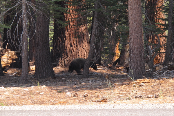
Then on Wednesday night at about 9:30 p.m., a yearling walked right into my camp and poked at the bear locker, while I was sitting around the campfire with three other folks. I ran him off; he was still too young not to be afraid of people who yell at him, and too inexperienced not to wait until everyone in the campground was asleep. I heard folks in the nearby campsites yelling at him for the next couple of hours until he finally went elsewhere.
There wasn't a bear problem when I first camped in the Mammoth area 32 years ago, but since then they've migrated over from Yosemite. Every developed campsite has a bear locker now, and you have to be very diligent about food management when you're wilderness camping...but you already knew that. :mrgreen:
Anyhow, I might try for the Kings Canyon area in September or October, depending on the fires, the wind, the weather, and getaway opportunities. It's closer, and usually the nights are a bit warmer later in the year than points farther north.
Slartibartfast
Well-known member
- Joined
- Sep 25, 2011
- Messages
- 318
- Reaction score
- 1
Sorry to hear that you had to cancel Vito, but certainly glad that you & yours were never in any real danger. I'm up in Tahoe myself, so obviously we're all keeping a sharp eye on this one as well. Here's a link to an update on the fire, if anyone's interested, from friday evening.
http://goldrushcam.com/sierrasuntimes/index.php/news/mariposa-daily-news-2013/157-august/9296-aspen-wildfire-in-the-sierra-national-forest-update-for-friday-evening-august-2-2013
As of friday night the fire was at 17,791 acres with 50% containment. $17.2 million cost so far and 1,941 personnel on fire.
:arrow:
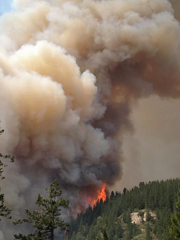
Impressive pic of a smoke plume off the Aspen fire.
http://goldrushcam.com/sierrasuntimes/index.php/news/mariposa-daily-news-2013/157-august/9296-aspen-wildfire-in-the-sierra-national-forest-update-for-friday-evening-august-2-2013
As of friday night the fire was at 17,791 acres with 50% containment. $17.2 million cost so far and 1,941 personnel on fire.
I love this attitude - you'll never make it if you can't hit a curve!Vito":ql62nn7j said:Ah, well, Kirk...by now it's no surprise that life is full of surprises, amigo...and they're not always pleasant. But expectations are the root of disappointment, and I made up the former, so I can drop the latter. I got outa there with my life intact and my sanity intact, which isn't a bad outcome, considering the alternatives.
:arrow:
Impressive pic of a smoke plume off the Aspen fire.
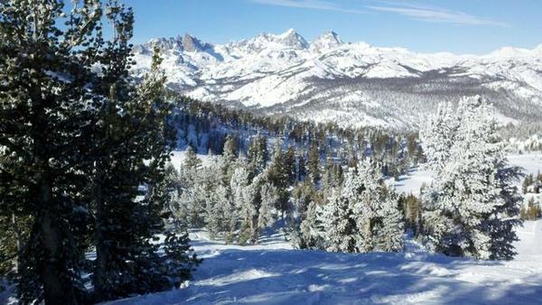
With all due respect, I beg to differ. Here's what the Minarets are really supposed to look like...:cheers: :lol:Vito":ql62nn7j said:Here's what the view from Minaret Vista is supposed to look like:
[/img]